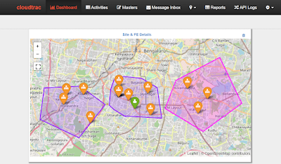
In projects involving multiple sites, accurate location tracking plays a crucial role in ensuring data integrity and accountability. Each site is mapped within a defined polygon area and tagged with specific latitude-longitude coordinates.
To streamline operations, The Cloudtrac platform uses geofencing to manage Field Executive (FE) actions:
Check-in Validation: FEs must be physically within the project polygon to check in. Attempts outside this boundary will trigger an error.
Status Update Restrictions: Once a service ticket is created, the FE must be within a 200-meter radius of the designated site to update the ticket status.
"Your location is out of the premises to update the Status! Please be in the 200 mtrs radius to update the Status."
Accurate location logging not only improves operational reliability but also ensures that all field activities are performed within authorized boundaries—strengthening compliance and data integrity across projects.
While traditional geo-fencing use cases focus on specific, pinpoint locations like individual sites, real-world scenarios often demand broader applications. These include larger geographies such as city-wide deployments, project zones spanning multiple regions, or custom-defined boundaries.
Supporting Two Geo-Fence Models
Radius-Based Validation:
For individual sites with a fixed latitude and longitude, a radius check (e.g., 100–200 meters) is typically sufficient. Used extensively in status updates and check-ins.Polygon-Based Geo-Fencing:
More complex scenarios require polygon-based geofences, where a site or region is represented by a set of coordinates forming a boundary (potentially from a KML file or a predefined map shape). This demands an extended or new standard service capable of:Accepting updated latitude-longitude values (e.g., from image uploads or field updates).
Comparing the received location against the geo-fence polygon.
Returning a decision:
Inside the boundary → Accept and proceed.
Outside the boundary → Reject with a prompt or error message.
This flexible validation approach ensures that location-specific operations, whether for a single site or an entire project region, are handled efficiently and securely. By evolving our geo-fencing framework to include both radius and polygon-based checks, Cloudtrac Platform enables a more robust and scalable solution for field force tracking and compliance automation.


Comments
Post a Comment